
La Niña watch means more dry weather possible for southeastern United States
The Southeast Climate Consortium and the National Oceanic and Atmospheric Association (NOAA) have issued a La Niña watch, meaning it is more likely than not that La Niña will redevelop in the Pacific Ocean in the next one to three months.
La Niña refers to a state of the tropical Pacific Ocean in which surface temperatures along the equator from South America to the central Pacific turn colder than normal. La Niña can be thought of as the opposite of El Niño, in which the same area of the Pacific is much warmer than normal.
Florida State University is a member of the Southeast Climate Consortium, a partnership of eight universities in Florida and the Southeast aimed at bringing seasonal climate prediction to better use in the management of agriculture and natural resources in the southeastern United States. FSU also is a partner in the Florida Climate Institute with the University of Florida.
La Niña typically brings fall and winter weather patterns to parts of the Southeast that are warmer and drier than normal. Historically, the peninsula of Florida averages rainfall 40 percent to 60 percent below normal in the months of November through March during La Niña events. Temperatures over the entire area average 3 to 4 degrees warmer than normal. The onset of warm and dry conditions normally begins in September, and the pattern intensifies as the season progresses.
"Last year, the Pacific Ocean slipped into one of the strongest La Niñas on record and was a key trigger for the development of drought in Florida and the Southeast as well as unprecedented drought in Texas and Oklahoma," said David Zierden, the state climatologist of Florida and an associate in research at FSU's Center for Ocean-Atmospheric Prediction Studies.
Historically, there is a tendency for strong La Niña events to last for two or more years. More recently, ocean temperatures along with wind and cloudiness patterns over the Pacific are indicating that the redevelopment of the cold water is likely after a summer of neutral conditions.
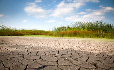
Crops in parts of the Southeast were already suffering from extremely dry and hot conditions earlier this summer. The three-month period of April through June was the driest on record since 1895 for the western Florida Panhandle and southern Georgia, while June ranked as one of the warmest on record. Southern Alabama, southern Georgia, and the western Florida Panhandle are designated as experiencing moderate to severe drought, according to the U.S. Drought Monitor.
The expected dry pattern could prolong or even worsen the widespread drought affecting the region. Potential deficits in rainfall during the winter in these areas can be critical, as winter is the primary recharge season for surface and groundwater.
"Due to the dry spring, many fields were planted late this year. A dry fall could reduce yields for non-irrigated fields," said William Birdsong, regional agronomy specialist with Auburn University Extension, referring to the peanut and cotton crops in southeast Alabama. "But drier conditions would benefit harvest operations, and La Niña favors small winter grains such as wheat, oats and rye."
Farther south, the water level in Lake Okeechobee is still well below normal and has little chance to recover during what is left of the summer rainy season. According to Geoff Shaughnessy, meteorologist with the South Florida Water Management District: "There is only about a 10 percent chance of the lake recovering this season, and that would only be in the event of one or more tropical systems."
The impact of La Niña is already being seen in the Atlantic hurricane season. The state of the Pacific Ocean is a primary factor in seasonal hurricane forecasts from the National Oceanic and Atmospheric Administration, Colorado State University and FSU. The La Niña phase has been shown to lead to more active hurricane seasons. La Niña tends to favor hurricane paths that curve northward and threaten the East Coast of the United States.
La Niña also brings the potential for a very active wildfire season to the state of Florida. Acreage burned is often more than double the average in La Niña years, as was seen in the active seasons of 1998 and 2001.
Warmer temperatures may slow the necessary chill accumulation in flowering fruits such as blueberries, peaches and strawberries but may enhance development of other crops. The forecasted warm and dry conditions are unfavorable for the production of winter forage for cattle when irrigation is not available. While mild freezes can be expected every year in North and Central Florida, La Niña reduces the risk of severe freezes in the citrus and vegetable belts.
For more detailed information on La Niña and climate forecasts, visit www.coaps.fsu.edu/climate_center and www.agroclimate.org. David F. Zierden of FSU's Center for Ocean-Atmospheric Prediction Studies can also be reached at (850) 644-3417 or zierden@coaps.fsu.edu.
"Last year, the Pacific Ocean slipped into one of the strongest La Niñas on record and was a key trigger for the development of drought in Florida and the Southeast as well as unprecedented drought in Texas and Oklahoma."
David Zierden
Florida State University Center for Ocean-Atmospheric Prediction Studies